Loudoun County will host a community meeting about the Villages of Paeonian Springs and Waterford Interconnected Community Water and Wastewater Systems project Tuesday, October 28, 2025, at 6:00 p.m. in the large meeting room at the Rust Library, 380 Old Waterford Road NW in Leesburg. Find more information online here.
The Waterford Foundation is working closely with Loudoun County and our community to ensure that any solutions to our longstanding water challenges preserve the unique historic character of our National Historic Landmark village. Clarkes Gap Road, a state scenic byway and a major entrance to Waterford is likely to be impacted by a Loudoun County project to design and build an interconnected water/wastewater system serving Waterford and the nearby village of Paeonian Springs. Below, find an explanation of the water issues faced by Waterford residents, concerns about impacts of possible solutions, and the Foundation’s position and values as it continues to monitor the progress of this Loudoun County project.
Key Points
- Water quantity and quality issues faced by residents of Waterford and nearby Paeonian Springs constitute a public health concern as well as a threat to the Waterford National Historic Landmark.
- Loudoun County is currently in the design phase of a project to bring community water and sewer service to Waterford and Paeonian Springs via interconnected systems that serve both historic villages.
- The extent of impacts to Clarkes Gap Road and its adjacent property owners from the construction on and ongoing operation of the new systems is not fully known at this stage of the design, and these impacts will be studied and refined as the design matures.
- The Waterford Foundation continues to monitor the project as it progresses, and holds the following values when assessing the impacts of proposed solutions:
- The Waterford Foundation will support proposals that promote the continued long-term integrity of the Landmark
- Changes to the landscape, including along roadways such as Clarkes Gap Road, should contribute to the rural character, maintaining features such as the open field patterns, wooded hedgerows, and board fencing typical of the area.
- Threats to the Landmark should be addressed with the support of and not at the expense of the surrounding community.
Waterford Community Water Project Background – 2019 to 2022
Despite its name, the village of Waterford has not always had plentiful water for its inhabitants throughout its nearly 300 year history. Waterford’s historic homes and commercial buildings are currently served by private wells, some of which are shared across property lines. Some Waterford homes still rely on historic hand-dug wells, which are vulnerable to contamination and do not meet modern health standards. Modern drilled wells may fail due to lack of available water, may provide less water than the household requires, and/or may provide water with such poor quality that it requires significant treatment before use. Together, all of these issues contribute to the water insecurity which poses a threat to the preservation of the Waterford National Historic Landmark. As stewards of the Waterford National Historic Landmark, the Waterford Foundation has an interest in monitoring and addressing threats to the Landmark. As such, the Foundation has been studying the issue and developing positions on possible solutions for many years.
Water Insecurity: A Threat to the Waterford National Landmark
Water insecurity impacting multiple parcels throughout the historic village threatens the integrity of the National Historic Landmark, as homes without adequate and/or clean water are not habitable. Non-habitable homes are more likely to be lost due to neglect or abandonment. The Landmark loses its integrity and may lose its designation entirely if sufficient numbers of contributing resources are lost. Therefore, water insecurity poses a direct threat to the Waterford National Historic Landmark and needs to be addressed.
Possible Solutions to Water Insecurity
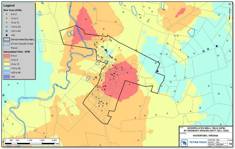
In response to a community petition in 2019, Loudoun County Department of General Services began a community water feasibility study to determine the extent of the water insecurity issue and identify and rank solutions that could ensure that each parcel in the historic village was served with adequate, clean water. The study considered three possible solutions: new private wells, new shared wells serving a small number of parcels, and a new community-wide water system. That feasibility study was completed in 2022 and found that the lack of available clean water for several parcels constitutes a public health concern and identified the preferred solution to be a new community-wide system. The primary points in this recommendation are:
- Drilling new wells on water insecure parcels is not effective or not possible due to one or more factors, including, but not limited to:
- small parcel size in more densely developed parts of the village limits or precludes new drilling sites,
- ground contamination within the parcel precluding new drilling sites, and
- low transmissivity of water through the underlying geology leading to low to zero water yield.
- Shared wells across property lines present a legal complication for property owners, and disputes over water quantity and/or quality delivered to neighboring parcels create difficult neighbor relationships and potentially costly and contentious legal battles.
Will a Community Water System Pose a New Threat to the Landmark?
To determine whether a community system is the right solution, we must consider whether such a system will itself present a threat to the Landmark. Some possible ways that a community water system may negatively impact the Landmark are:
- The construction of water infrastructure within the Landmark that is not sensitively designed to blend into Waterford’s characteristic architecture and agrarian landscape impacting the integrity of the Landmark.
- Enabling uncontrolled development of currently undeveloped parcels within the Landmark
- Condemning easements on protected open lands surrounding the village for the construction of water system infrastructure.
- Costs to construct and connect to a community water system may be imposed on property owners. Those costs may be significant and could impact a property owner’s ability to afford to maintain their property.
The Waterford Foundation reviewed these possible threats in 2022 in response to the published feasibility study and found the following:
- Of the undeveloped parcels within the historic village (and within the proposed water system service area) none are currently unable to be developed due to a lack of available water. Thus, a community water system serving those parcels would not by itself change the development potential of those parcels. In most cases those parcels could be developed today, with or without community water. Most are seen as unlikely to be developed due to other factors, such as small lot size, being landlocked by other parcels, or zoning restrictions. Any development within the Waterford Historic District requires review and approval by the Loudoun County Historic District Review Committee and review and approval with respect to the zoning ordinance by the County Planning and Zoning Department.
- A funding mechanism for design and construction of a community system has not been developed; however, County project staff have indicated that grant funding is likely to be available to supplement funds from the County itself. They do not anticipate establishing a special tax district as would be required to pass the costs on to the property owners directly. Connection costs for customers will depend on the specific plumbing and infrastructure needs for each property and are difficult to predict in a general sense. Property owners currently bear 100% of the costs of maintaining their private wells and water supply systems or for replacing them if equipment fails or a well runs dry.
- The feasibility study presented a conceptual design of a community water system that identified the Water Street Meadow as a possible site for water infrastructure. This property is owned by the Waterford Foundation and under easement with the Virginia Department of Historic Resources, which would preclude its use for such development without condemning or abandoning the easement. Many other open spaces surrounding the village are also under easement, making them unsuitable for water infrastructure. The Foundation highlighted this issue for County project staff and emphasized the Foundation’s position that easement restrictions must be respected to maintain the integrity of the Landmark.
Following their review of the study and the issue, the Waterford Foundation Board of Directors summarized their support for pursuing further design of a community water system in a letter to the Loudoun County Department of General Services in June 2022.
Interconnected Paeonian Springs – Waterford Water/Wastewater System – 2023 to present
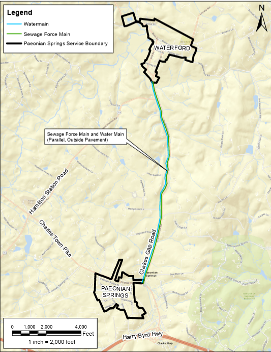
In parallel with efforts in Waterford, the nearby village of Paeonian Springs also faced water insecurity and faced the additional challenge of failing septic systems. As such, Loudoun County Department of General Services (LCDGS) also conducted a feasibility study for community water and wastewater in Paeonian Springs and found that both systems were needed to address critical public health issues in that community. Having completed studies for both Waterford and Paeonian Springs, LCDGS staff noted an opportunity granted by the proximity of the two communities to build combined systems that would serve both communities at a lower cost than separate systems for separate communities. A new technical feasibility study was launched by LCDGS in February 2023 at the direction of the Loudoun Board of Supervisors to further explore the feasibility of combined systems to meet the needs of both communities. The study was completed in October 2024 and presented to the Loudoun County Board of Supervisors on November 19, 2024. It identified a conceptual solution that placed water infrastructure outside the Waterford National Historic Landmark between the two villages and proposed that water/wastewater infrastructure connecting the two villages would follow the Clarkes Gap Road corridor, with the pipes running through the road right-of-way.
While the feasibility study for the interconnected system was underway, the WF Board reviewed the proposed interconnected water/wastewater project for its potential impacts to the Landmark, both positive and negative. The following important points were noted:
- Proposed service districts for the two villages under the interconnected design will limit the potential for connections to the new system to only those parcels within the two villages. Parcels along Clarkes Gap Road would not be eligible to connect to the new system. Because of this, and because all development is controlled by the County Department of Planning and Zoning as it administers the current comprehensive plan as implemented through the zoning ordinance, an interconnected system between the two villages will not change the development potential of parcels along Clarkes Gap Road, a portion of which lies within the Waterford National Historic Landmark.
- Waterford’s wastewater facility is reaching the end of its useful life and must be upgraded to new technology to meet current EPA standards by 2027. The upgrade of this existing facility presents an opportunity to integrate service to nearby Paeonian Springs during the planned upgrade.
- Commission permits for new water and wastewater facilities require studies to demonstrate that the facilities will meet standards in highly regulated industries. Therefore, a combined wastewater facility will be required to meet discharge requirements that minimize negative impacts to the local streams and groundwater, and a combined water system (and its wells) will be required to demonstrate that it will not negatively impact nearby private wells and streams.
- A combined system serving the two villages could have sufficient combined capacity to provide fire suppression service to the villages, something that both villages currently lack. As loss through fire is a significant threat to Waterford’s historic buildings, this would be an advantage in protecting the Landmark from future catastrophic fire events.
- The interconnected system facilitates the placement of water infrastructure further away from Waterford’s village center, making it more likely that a location can be found outside of the Landmark and on land that is not protected by conservation easements.
Open Questions and Concerns
While the interconnected system proposal presents several attractive opportunities, much is yet unknown about the implementation details of such a system. Those unknowns include:
- The location and yield of the water supply system, including specific well sites and yields.
- The exact path of water supply mains from the water supply system to the two villages and wastewater pipes from Paeonian Springs to Waterford, whether they will follow Clakes Gap Road and be installed under the pavement or adjacent to the pavement within the existing right-of-way.
- How the location and installation of water and wastewater pipes will impact the landscape along Clarkes Gap Road during and after construction. Whether and how many trees will need to be removed or grading adjusted.
- Whether or to what extent rights-of-way will need to be expanded or created along Clarkes Gap Road, impacting the usable land of property owners along the roadway.
- The timeline and expected duration of construction, and its impacts to local and through traffic on Clarkes Gap Road.
These open questions can only be answered with further study and further design of the proposed interconnected system. After reviewing and discussing the issue, the WF board voted to send a letter of support to the Loudoun County Department of General Services project staff confirming their continued support of the project and the reasons for that continued support. At their November 19, 2024 meeting the BOS endorsed the interconnected system proposal and directed that funds be allocated to support easements, land use approvals, and the costs associated with increasing the capacity of the existing Waterford wastewater treatment plant as needed.
Waterford Foundation Preservation Values
The WF Board commits to continued monitoring of the project and analysis of its possible impacts to the Landmark and the Waterford community. In its analysis, the WF Board will compare the predicted outcomes to the following priorities and values:
- The preservation of the Waterford National Historic Landmark is the mission of the Waterford Foundation and therefore, the Board will support proposals that promote the continued long-term integrity of the Landmark.
- The rural landscape surrounding the village of Waterford is a contributing resource integral to the significance of the Landmark. Changes to the landscape, including along roadways such as Clarkes Gap Road, should contribute to the rural character, maintaining features such as the open field patterns, wooded hedgerows, and board fencing typical of the area.
- Historically, as an agricultural service village, Waterford’s village residents and those who lived in the surrounding rural areas worked together and supported each other. Although the economy of the village no longer directly depends on the surrounding farmland, today’s village residents continue to work together with the nearby community to preserve open lands within the landmark and address common challenges such as the increased traffic through our rural area and other impacts of development throughout our region. Threats to the Landmark should be addressed with the support of and not at the expense of the surrounding community.
The Waterford Foundation remains committed to working with county leaders, engineers, and our community to ensure that solutions protect both our residents and our Landmark for generations to come. Please feel free to share your feedback with the Waterford Foundation board and staff via the contact form below.
Resources:
- Loudoun County Project Webpage, including an archive of Loudoun Board of Supervisors actions with respect to this project
- Waterford Citizens’ Association community water links and history page
- Waterford Foundation Letters of Support